Review of ‘Winster Village Map’, by Winster Village Map GroupThis review is by Julie Bunting, and was published originally in The Peak Advertiser, the Peak District's local free newspaper, on 20th October 2003, and is reproduced with Julie's kind permission.
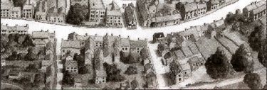
The two-sided map is in colour, opening up to 430 x 735mm and folding down to pocket size. It offers a great deal of interest to walkers and visitors to this historic leadmining village. A watercolour 'aerial' view of Winster itself is featured on one side of the map, with sketches and descriptions of two dozen points of interest such as the distinctive local gennels, the Market House, lead mines and the old Poorhouse. A wider area around Winster is shown on the reverse, similarly offering fascinating close-ups, from a find of Anglo-Saxon jewellery to rare wild flowers and ancient trackways which today provide some great walks. Artist Andy Birkby produced specially commissioned watercolours for the map and has not stinted on detail, as witness time-worn stone steps and massive stone slabs capping an old mine shaft. Winster Village Map Group received a grant from the National Lottery 'Awards for All', enabling every household in the village to receive a free copy of the map. Review by Julie Bunting |
|||